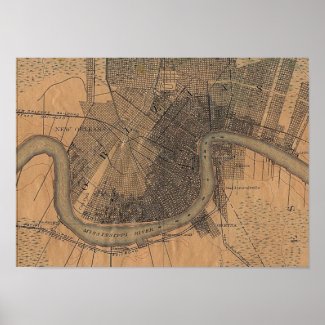
New Orleans Map 1891 Posters from Local Artist
New Orleans Map 1891 Posters from Zazzle.com
Sauvé's Crevasse
From Wikipedia, the free encyclopedia:
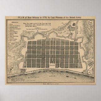
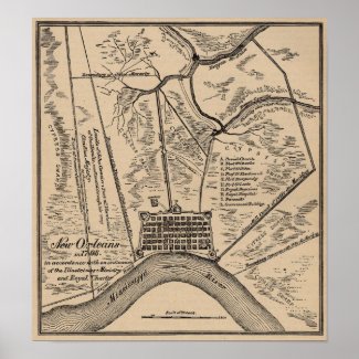
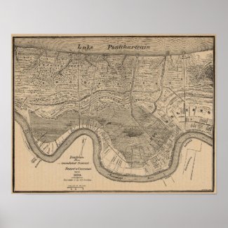
"Sauvé's Crevasse was a Mississippi River levee failure that flooded much of New Orleans, Louisiana in 1849. In 1849 the Mississippi reached the highest water level observed in twenty-one years. Some seventeen miles (27 km) up river from the city of New Orleans in Jefferson Parish lay a plantation belonging to Pierre Sauvé, in what is now River Ridge, Louisiana. There, on the afternoon of May 3d, the levee gave way. At once it was seen impossible to stem the raging waters. At first the people of the city hoped that the flood would find its way into Lake Pontchartrain by some channel or the other, before reaching the city. But the swamp rapidly filled; the water approached the outskirts of the town; and it was then too late to throw up any adequate defenses. By May 15th the water was at Rampart Street. The First Municipality went to work on a small levee which lay along the lower bank of the Carondelet Canal, and raised it sufficiently to shut out the flood from that part of the city, allowing some of the water to drain via the canal into Bayou St. John and thence into Pontchartrain, and saving much of the city below the Canal. This was a significant success, which kept the flooding out of the Faubourg St. John, Marigny, and other downriver portions of the city, and by providing an outlet for the waters prevented even deeper and more widespread flooding above the Canal. However most of what is now Uptown New Orleans and the New Orleans Central Business District were badly flooded. The water spread from the low-lying "back of town" into the higher ground closer to the River, and attained its highest point on May 30th. In the CBD it reached Bacchus (Baronne) Street from the upper limits of Lafayette to Canal; and sometimes, where the ground was low, it ran over into Carondelet. Further Uptown, between Louisiana and Napoleon Avenues the flooding stopped just short of Magazine Street. In Carrollton, Louisiana, above Canal Avenue (Carrollton Avenue) the waters reached to Forth Street (Oak), and below to Burthe. Waring & Cable (Social Statistics of Cities, Reports on New Orleans) reported, "About 220 inhabited squares were flooded, more than 2,000 tenements were surrounded by water, and a population of near 12,000 souls either driven from their homes or living an aquatic life of much privation and suffering." This figure may be only for the city of New Orleans as then constituted, with its upper limit at Felicity Street; much of what would later become Uptown New Orleans was then the towns of Lafayette, Bologny, Jefferson, and Carrollton. For weeks the efforts to close the crevasse had proven unavailing. Then two engineers, George T. Dunbar and Surgi, undertook the task, and with carte blanche as to methods and materials, succeeded after seventeen days of heroic exertion, in staunching the flood on the 20th of June. The waters, however, did not disappear till nearly a month later. By June 22d the principal streets were clear again. Then heavy rains fell, washing away the flood deposits, and the city began to resume its normal aspect. Public property had suffered extensive damage, particularly in the Second Municipality (what is now the CBD and Lower Garden District). Pavements and gutters and gutter-bridges had to be generally replaced. In 1850 the Second Municipality found it necessary to levy a special tax of $400,000 to offset "actual expenditures on streets, wharves and crevasses." Somewhat tardily, the council of that municipality erected a levee on Felicity Street, from the point where the Claiborne Canal intersected the New Basin Canal, to the corner of Apollo (Carondelet) Street. While New Orleans has experienced numerous floods large and small in its history, the flood of 1849 was of a more disastrous scale than any save the flooding after Hurricane Katrina in 2005; see Effect of Hurricane Katrina on New Orleans. Katrina flooded a larger total urban area. However much of what would become the city of New Orleans and its suburbs in Jefferson Parish was still swampland when it was flooded by the Crevasse of 1849. The water level of Mississippi River which flooded the city in 1849 was higher than that of Lake Pontchartrain which flowed into the city after Hurricane Katrina in 2005. This is particularly evident in areas of Uptown where higher water levels were recorded in 1849 in places which flooded again in 2005. Also, the flooding of 1849 extended into a significant part of Uptown that remained dry during the flooding after Hurricane Katrina. New Orleans has not experienced flooding from the Mississippi River since Sauvé's Crevasse, although it came dangerously close during the Great Mississippi Flood of 1927."
No comments:
Post a Comment
omments Are Moderated, no SPAM.